Hurricane Helene (2024) Historical Storm Tracking & Data - Cruising Earth
Hurricane Helene (2024) Historical Storm Tracking
Category 4 Hurricane Helene (2024) Historical Storm Data
Landfall Data
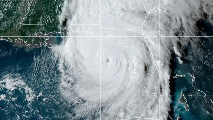
Date/Time: 9-26-2024 11:20 PM EDT Landfall City/State: Taylor County, Florida Location: 29.98°N -83.79°W Moving: NNE at 24 mph Minimum Central Pressure: 938 mb | 27.70 inHg Maximum Sustained Winds: 140 mph (Cat 4) Hurricane Force Winds Extend Out: 60 miles Tropical Storm Force Winds Extend Out: 310 miles
Date/Time: 9-26-2024 11:20 PM EDT Landfall City/State: Taylor County, Florida Location: 29.98°N -83.79°W Moving: NNE at 24 mph Minimum Central Pressure: 938 mb | 27.70 inHg Maximum Sustained Winds: 140 mph (Cat 4) Hurricane Force Winds Extend Out: 60 miles Tropical Storm Force Winds Extend Out: 310 miles
Category 4 Hurricane Helene (2024) Historical Storm Path
Landfall Location
Landfall City/State: Taylor County, Florida
Landfall Location: 29.98°N -83.79°W
Time Of Landfall = 9-26-2024 11:20 PM EDT
Movement At Landfall = NNE at 24 mph
Map Legend:
- Tropical Depression
- Tropical Storm
- Hurricane
- Projected Landfall
- Tropical Storm Wind Field
- Hurricane Wind Field
Landfall occurs when the center of the tropical cyclone moves across the coast.
Zoom In/Out On The Map Above To View Details Of The Landfall Location
Severe Weather Information
Cruising Earth is not an official source for severe weather information. Please refer to your region's official weather service as your primary source for severe weather updates and decision-making to keep you and your family safe.
Cruising Earth is not an official source for severe weather information. Please refer to your region's official weather service as your primary source for severe weather updates and decision-making to keep you and your family safe.
Weather Related Cruise Delays & Itinerary Changes
Check directly with your cruise line for any potential weather-related delays or itinerary changes. Many cruise lines also offer online sign-ups for weather alerts via email or text message specific to your cruise.
Check directly with your cruise line for any potential weather-related delays or itinerary changes. Many cruise lines also offer online sign-ups for weather alerts via email or text message specific to your cruise.